Reading Time: 2 minutes
| What’s New | What is it? | Why is it useful? | Use tips |
|---|---|---|---|
|
Common To all AviationSentry Online Users – Platinum Service Level |
|||
| High Ice Water Content Layer | Provides a forecast of ice crystal potential at 11 unique flight levels, from 30,000 to 41,000 feet. | Ice crystal concentrations can cause significant power loss or engine stall in certain aircraft. | Found in Layered Map –> Layers Menu –> Enh Flight Hazards |
| Europe Weather Station and Forecast density | Increased the density of weather observations (50%) and forecasts (29%) throughout Europe. | This provides users with a more accurate representation of actual and anticipated conditions. | Visualize the station increase in the Layered Map –> Locations –> Forecast Locations |
|
Common To all AviationSentry Online Users |
|||
| Improved Terminal Area Forecast (TAF) Layer depiction | The colored icon to represent the expected flight category conditions for a given TAF is now based on the current time rather than the TAF issue time. | The issue time of a TAF can be anywhere from 0-12 hours in the past. In evolving weather conditions, this can provide a false sense of expected conditions. Utilizing the current time period of the TAF provides the user with increased situational awareness of flight category conditions | |
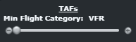
| Terminal Area Forecasts (TAF) Layer Filtering | Introduced the capability to filter the display of the TAF layer based on the minimum expected forecast flight category. | This allows the user to focus on the TAF locations with reduced fight category conditions. | New Layer Option Menu:
|
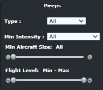
| Pilot Reports (PIREP) Layer Filtering | Users now have the capability to filter the display of the PIREP layer based on:
· Type · Intensity · Aircraft Size · Flight Level |
Previously, all PIREP were shown, forcing the users to manually sift through the data. This enhancement provides the user with options to configure the display more relevant to their operation. | New Layer Option Menu:
|
| Low-altitude global Winds Aloft layers | Addition of 2 new global forecast wind levels in the layered map, 1000 and 3000 feet. This increases the number of levels available from 9 to 11. | Provides users with enhanced awareness of wind speeds and directions in the lower atmosphere to optimize decision-making. | The two new forecast levels can be found in the Winds Aloft layer options menu. |
| Menu option to remove unofficial observations from Visibility layer | Added a layer menu option to the visibility layer to present users with the choice of removing unofficial weather observations. | Enables users to have increased confidence when making weather related decisions based on current observations. | Found in Layered Map –> Layers Menu –> Observations –> Visibility |